Aquaveo Arc Hydro Groundwater Toolkit v3.5.0.25954 for ArcGIS 10.8
Functional Features
1、Groundwater Analyzer
Import various datasets (wells, time series, cross sections, volumes) into your geodatabase, manage layer symbols in ArcMap and ArcScene, plot and map time series, and create common products such as water level, water quality, and flow direction maps.
2、MODFLOW Analyst
Edit, archive, and visualize MODFLOW models in ArcGIS. The tools in this toolkit enable you to import an existing model into a geodatabase and georeference that model so you can visualize and analyze results and other GIS data in context, as well as modify the model with GIS elements.
3. Subsurface Analyzer
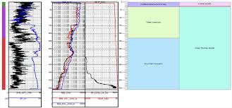
Create and visualize 2D and 3D geological models, starting with the classification and visualization of borehole logs, the creation and editing of cross-sections, and the generation of 3D geo-sections and geo-volumes.
Whether you are in the oil, geotechnical, mining, or groundwater industry, the new Subsurface Analyst will manage all your subsurface data in ArcGIS.









Reviews
There are no reviews yet.