


Landmark GVERSE GeoGraphix 2022.1.21669 Win64
Available versions: 2022.1, 2019.2 , 2019.1
Available Landmark Software: EDT, Promax seisspase , GeoGraphix, Drillworks, Aries, NeTool, Nexus, DecisionSpace Geosciences, DecisionSpace Petrophysics, OpenWorks, DecisionSpace InSite core, Recall Borehole, GeoProbe, HPTK, DSS, Permedia
GeoGraphix 2022.1 is an integrated product suite that incorporates shared data management and geological, petrophysical, and geophysical interpretation software. It utilizes a Sybase (SAP SQL Anywhere) database in GeoGraphix Discovery mode or accesses the OpenWorks SeisWorks (Oracle) database in Discovery on OpenWorks mode.
This release consists of the following:
GVERSE® Petrophysics
GVERSE® Petrophysics is a 64bit petrophysical application designed to assist geoscientists and petrophysicists in analyzing and interpreting well log data, and characterization of the reservoir using simple to advanced log interpretation workflows in a large multi-well multi-user environment.
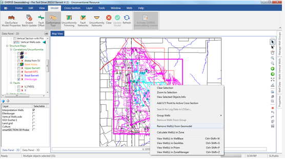
GVERSE® Geomodeling
An integrated environment for modeling that incorporates existing mapping and cross-section features of smart SECTION® with a newly built 3D View. It takes your smart SECTION interpretations to a whole new level with 3D modeling, while also enabling you to fully utilize the existing smart SECTION features.
GVERSE® Geophysics
An intuitive and easy-to-use seismic interpretation system with powerful 3D visualization and interpretation capabilities. GVERSE Geophysics enables geoscientists to execute end-to-end workflows for basic interpretation and more advanced geophysical tasks.
GVERSE® Field Planner
This application intelligently populates wells over an entire field based on defined hazards, lease areas, and constraints. It uses an advanced optimization algorithm to lay out hundreds of wells in minutes. It works with you by taking into account surface hazards, existing wells in the area, and lease boundaries to maximize lateral length in the zone.
Pro 3D
Enables interpreters to get the most from their data by quickly creating powerful and informative base maps, fence diagrams, and seismic backdrops. Using the Pro 3D window you can show IsoMap® structural surfaces, cultural layers, wells, seismic data, cross sections, and fence diagrams in the 3D Scene.
Field Planning
The advanced field planning tool is designed to reduce the time required for efficient field development. It provides the ability to create, save, analyze, and manage multiple field plan scenarios before committing them to the database. Designed for horizontal well plans, the Field Planner includes the determination of the optimum location and orientation of wells. These proposed wells can all be visualized by creating a layer for display in GeoAtlas™.


Reviews
There are no reviews yet.